PALM BEACH ATLAS
 Follow@PalmAtlas
Juxtaposed next to the most extensive, on the ground survey of the Island of Palm Beach, completed in the 1930's, Current Real Estate Trends, Sales and Opportunities are Explored
Palm Beach Atlas
by George S. Brockway Civil Engineer circa 1936
Only a few copies were ever printed - fewer still exist
This copy of the Atlas was a working copy from a Palm Beach Real Estate Firm
Many sheets contain markups with 1940's... Original lot sizes, property prices and owner names
~70 web pages - one for each sheet - a working index - about page - and more
A historical reference site to Palm Beach Real Estate
Bound in a 1920's era top-lock ledger style binder enabled removal of individual full sheets without damage. Pictures of the intact Atlas can be seen at the link below
Palm Beach Atlas About
Along with the property owner names and lot sizes printed by Brockway, many buyers names and, of great interest, updated lot sizes and property prices paid were pencilled in by the Realtor
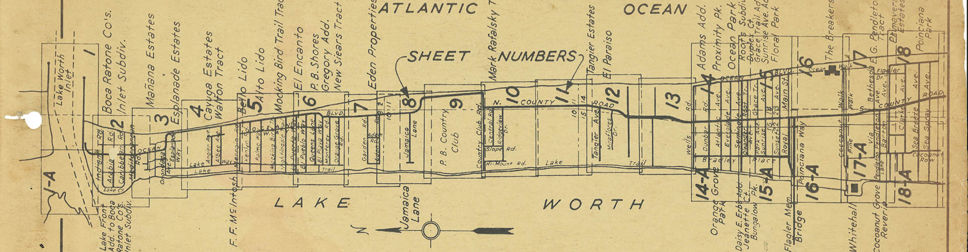
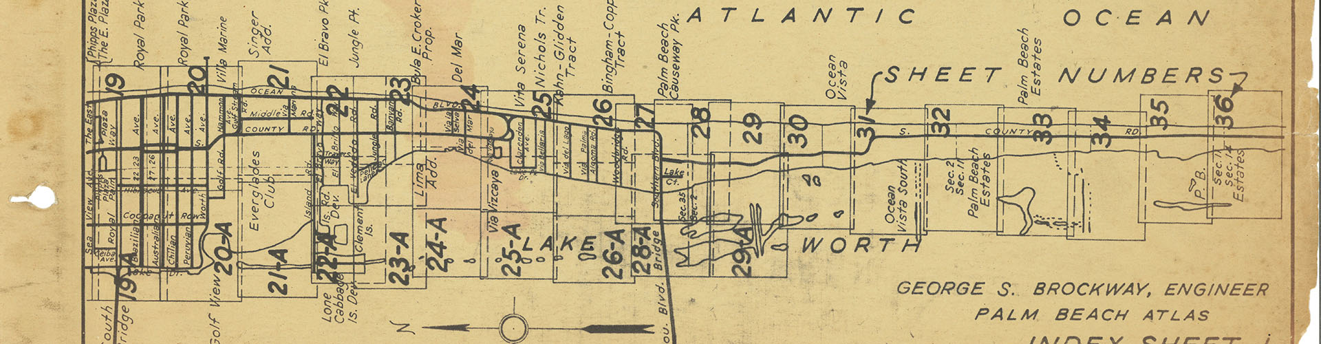
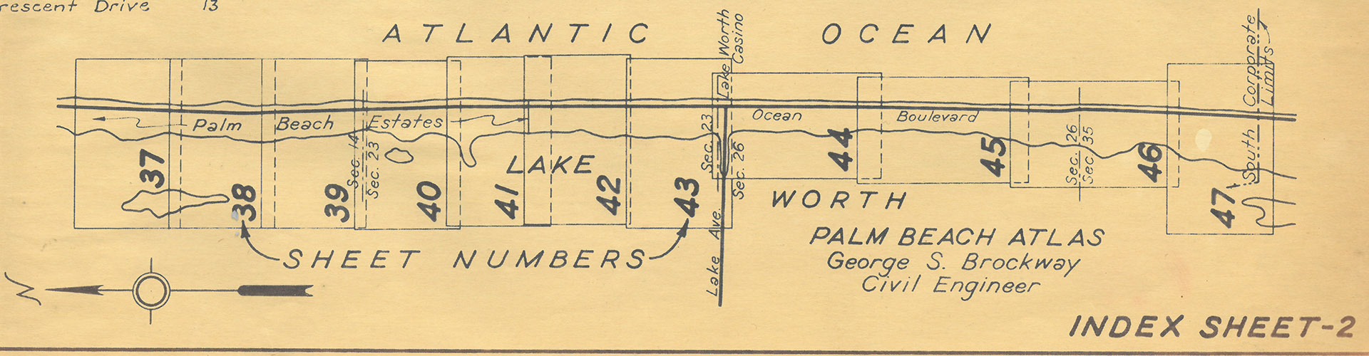
Each sheet is legal size 8.5 x 14 inches
Links to each sheet at bottom
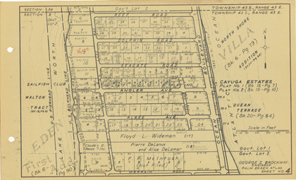
Sheet 4
Sheet 4 is bounded by Reef Rd. on the North and Merrain Rd. on the South. East to West it covers the full island width from Lake Worth to the Atlantic Ocean.
Palm Beach Atlas Sheet 4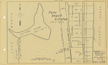
Sheet 33
Sheet 33 Covers just north of where Sloans curve is today. From Lake Worth to the Atlantic Ocean. Includes former Edward F. Hutton Estate and Hunters Island.
Palm Beach Atlas Sheet 33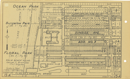
Sheet 15-A
Sheet 15-A Bordered by Seminole Ave. running south to Royal Poinciana Way and Lake Worth to N. County Road. Includes the old Biltmore Hotel and Beach Club
Palm Beach Atlas Sheet 15-A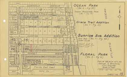
Sheet 15
Sheet 15 is bounded Seminole Ave. on the north and The Florida East Coast Hotel Co. (The Breakers) on the south. East to West it covers the area between N. County Road and the Atlantic Ocean.
Palm Beach Atlas Sheet 15THE BREAKERS HOTEL & WHITEHALL
Links to each individual sheet at the bottom of this page
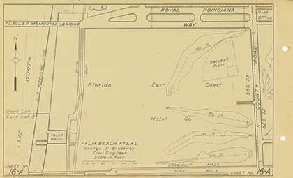
Sheet 16-A
Royal Poinciana Way south to the northern edge of the Flagler Museum and Lake Worth to S. County Road.
Palm Beach Atlas Sheet 16-A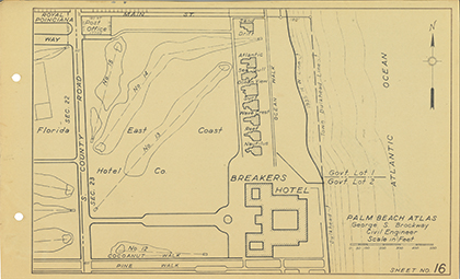
Sheet 16
Breakers Hotel and Breakers row cottages. S. county Road to the Atlantic.
Palm Beach Atlas Sheet 16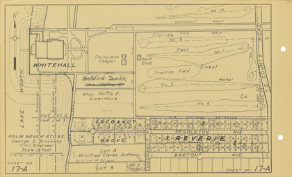
Sheet 17-A
Includes Henry Flager's Whitehall and the Poinciana Chapel. Notice how Cocoanut Row had not yet been extended thru the golf course.
Palm Beach Atlas Sheet 17-A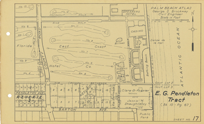
Sheet 17
Includes part of the original hotel, the casino, the pool and the Cabanas on the bathing beach.
Palm Beach Atlas Sheet 17- Palm Beach Atlas
Street Index - The Breakers Hotel
Whitehall - Palm Beach Atlas
Sheet 1 - Palm Beach Atlas
Sheet 1-A - Palm Beach Atlas
Sheet 2 - Palm Beach Atlas
Sheet 3 - Palm Beach Atlas
Sheet 4 - Palm Beach Atlas
Sheet 5 - Palm Beach Atlas
Sheet 6 - Palm Beach Atlas
Sheet 7 - Palm Beach Atlas
Sheet 8 - Palm Beach Atlas
Sheet 9 - Palm Beach Atlas
Sheet 10 - Palm Beach Atlas
Sheet 11 - Palm Beach Atlas
Sheet 12 - Palm Beach Atlas
Sheet 13 - Palm Beach Atlas
Sheet 14
- Palm Beach Atlas
Sheet 14-A - Palm Beach Atlas
Sheet 15 - Palm Beach Atlas
Sheet 15-A - Palm Beach Atlas
Sheet 16 - Palm Beach Atlas
Sheet 16-A - Palm Beach Atlas
Sheet 17 - Palm Beach Atlas
Sheet 17-A - Palm Beach Atlas
Sheet 18 - Palm Beach Atlas
Sheet 18-A - Palm Beach Atlas
Sheet 19 - Palm Beach Atlas
Sheet 19-A - Palm Beach Atlas
Sheet 20 - Palm Beach Atlas
Sheet 20-A - Palm Beach Atlas
Sheet 21 - Palm Beach Atlas
Sheet 21-A - Palm Beach Atlas
Sheet 22 - Palm Beach Atlas
Sheet 22-A
- Palm Beach Atlas
Sheet 23 - Palm Beach Atlas
Sheet 23-A - Palm Beach Atlas
Sheet 24 - Palm Beach Atlas
Sheet 24-A - Palm Beach Atlas
Sheet 25 - Palm Beach Atlas
Sheet 25-A - Palm Beach Atlas
Sheet 26 - Palm Beach Atlas
Sheet 26-A - Palm Beach Atlas
Sheet 27 - Palm Beach Atlas
Sheet 28 - Palm Beach Atlas
Sheet 28-A - Palm Beach Atlas
Sheet 29 - Palm Beach Atlas
Sheet 29-A - Palm Beach Atlas
Sheet 30 - Palm Beach Atlas
Sheet 31 - Palm Beach Atlas
Sheet 32 - Palm Beach Atlas
Sheet 33
- The Everglades Club
Worth Ave - Palm Beach Atlas
Sheet 34 - Palm Beach Atlas
Sheet 35 - Palm Beach Atlas
Sheet 36 - Palm Beach Atlas
Sheet 37 - Palm Beach Atlas
Sheet 38 - Palm Beach Atlas
Sheet 39 - Palm Beach Atlas
Sheet 40 - Palm Beach Atlas
Sheet 41 - Palm Beach Atlas
Sheet 42 - Palm Beach Atlas
Sheet 43 - Palm Beach Atlas
Sheet 44 - Palm Beach Atlas
Sheet 45 - Palm Beach Atlas
Sheet 46 - Palm Beach Atlas
Sheet 47 - Palm Beach Atlas
About